
Shirland topographic map
Click on the map to display elevation.
About this map
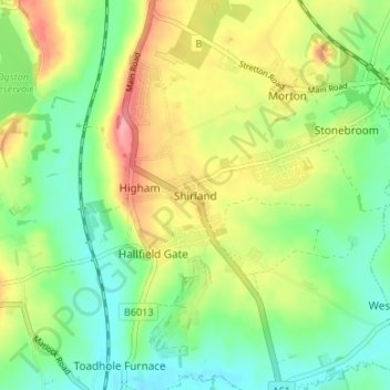
Name: Shirland topographic map, elevation, terrain.
Average elevation: 397 ft
Minimum elevation: 272 ft
Maximum elevation: 581 ft
Other topographic maps
Click on a map to view its topography, its elevation and its terrain.
North Wingfield
United Kingdom > England > Derbyshire > North East Derbyshire
Average elevation: 413 ft
Ogston Reservoir
United Kingdom > England > Derbyshire > North East Derbyshire > Woolley Moor
Average elevation: 449 ft
Doghole Wood
United Kingdom > England > Derbyshire > North East Derbyshire > Holymoorside
Average elevation: 466 ft
Brackenfield CP
United Kingdom > England > Derbyshire > North East Derbyshire
Average elevation: 551 ft
Dronfield Nature Park
United Kingdom > England > Derbyshire > North East Derbyshire > Dronfield > Unstone Green
Average elevation: 512 ft
Ashover CP
United Kingdom > England > Derbyshire > North East Derbyshire
By the 18th century, there were several thousand acres of unenclosed moorland in the parish of Ashover, principally covered with heath. The only paths across this wilderness for roads were tracks in the sand or heath with here and there a stone post on the hills or elevations to serve as guides to the…
Average elevation: 689 ft
Norwood Cottage Lakes
United Kingdom > England > Derbyshire > North East Derbyshire > Killamarsh
Average elevation: 305 ft
Grassmoor Country Park
United Kingdom > England > Derbyshire > North East Derbyshire > Corbriggs
Average elevation: 381 ft
Holmesfield
United Kingdom > England > Derbyshire > North East Derbyshire > Holmesfield
Average elevation: 764 ft