
Notch Peak topographic map
Click on the map to display elevation.
About this map
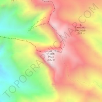
Name: Notch Peak topographic map, elevation, terrain.
Location: Notch Peak, Millard County, Utah, United States (39.14315 -113.40931 39.14325 -113.40921)
Average elevation: 7,986 ft
Minimum elevation: 6,135 ft
Maximum elevation: 9,547 ft
Other topographic maps
Click on a map to view its topography, its elevation and its terrain.
Fillmore
United States > Utah > Millard County
Fillmore is located at an elevation of 5,135 feet (1,565 m) in elevation. It lies in the Pahvant Valley, near the base of the Pahvant Mountain Range.
Average elevation: 5,197 ft
Delta
United States > Utah > Millard County
Delta experiences a cold semi-arid climate (Köppen BSk) with hot summers and cold winters. Because of Delta's altitude and aridity, temperatures drop quickly after sunset, especially in the summer. Winters are cold. Daytime highs in the winter are usually above freezing, but nighttime lows drop well below…
Average elevation: 4,649 ft