Geolocate

Fillmore topographic map

Click on the map to display elevation.

Fillmore

Fillmore is located at an elevation of 5,135 feet (1,565 m) in elevation. It lies in the Pahvant Valley, near the base of the Pahvant Mountain Range.

Wikipedia (CC-BY-SA 3.0)

About this map

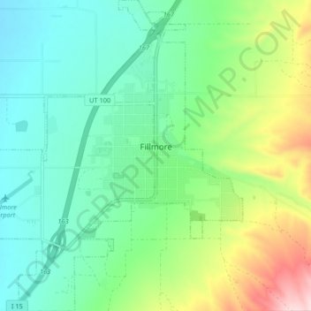
Name: Fillmore topographic map, elevation, terrain.

Location: Fillmore, Millard County, Utah, 84631, United States (38.93524 -112.37219 38.99876 -112.30076)

Average elevation: 5,197 ft

Minimum elevation: 4,898 ft

Maximum elevation: 5,935 ft

Millard County trails, hiking, mountain biking, running and outdoor activities

Other topographic maps

Click on a map to view its topography, its elevation and its terrain.

Sugarville

United States > Utah > Millard County

Average elevation: 4,590 ft

Sevier Lake

United States > Utah > Millard County

Average elevation: 5,000 ft

Notch Peak

United States > Utah > Millard County

Average elevation: 7,986 ft

Gear up for your next adventure:

👟Men's Trail Runners - Lightweight footwear for fast-paced exploration and light hiking
📶Satellite Messenger - Communication device off‑grid
📱Solar Portable Charger - Solar power bank for charging devices off‑grid
🩳Quick‑Dry Hiking Shorts - Comfortable and quick‑dry shorts for summer hiking
🏕️Family Camping Gear - Essentials for group camping trips

As an Amazon Associate, this site earns from qualifying purchases at no extra cost to you.