Geolocate

Bras topographic map

Click on the map to display elevation.

About this map

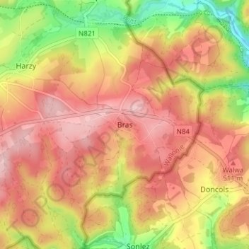
Name: Bras topographic map, elevation, terrain.

Location: Bras, Bastogne, Luxembourg, Wallonia, Belgium (49.96380 5.80038 50.00380 5.84038)

Average elevation: 1,542 ft

Minimum elevation: 1,188 ft

Maximum elevation: 1,775 ft

Other topographic maps

Click on a map to view its topography, its elevation and its terrain.

Noville

Belgium > Luxembourg > Bastogne > Bastogne

Average elevation: 1,549 ft

Flamierge

Belgium > Luxembourg > Bastogne > Bastogne

Average elevation: 1,407 ft

Gear up for your next adventure:

🦺Reflective Outdoor Gear - Safety gear for low‑light conditions
🪶LED Camping Lantern - Bright lantern for camp lighting
🧴Hand Sanitizer - Keep hands clean while hiking
❄️Traction Cleats - Prevent slips on icy trails during winter hikes
🔭Telescopic Hiking Pole - Adjustable pole for hiking stability

As an Amazon Associate, this site earns from qualifying purchases at no extra cost to you.