Geolocate

Noville topographic map

Click on the map to display elevation.

About this map

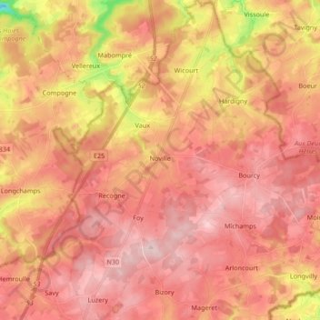
Name: Noville topographic map, elevation, terrain.

Location: Noville, Bastogne, Luxembourg, Wallonia, Belgium (50.01022 5.70631 50.11722 5.82459)

Average elevation: 1,549 ft

Minimum elevation: 988 ft

Maximum elevation: 1,821 ft

Other topographic maps

Click on a map to view its topography, its elevation and its terrain.

Bastogne

Belgium > Luxembourg > Bastogne > Bastogne

The municipality consists of the following districts: Bastogne, Longvilly, Noville, Villers-la-Bonne-Eau, and Wardin. The town is situated on a ridge in the Ardennes at an elevation of 510 metres (1,670 ft).

Average elevation: 1,657 ft

Foy

Belgium > Luxembourg > Bastogne > Bastogne

Average elevation: 1,660 ft

Bertogne

Belgium > Luxembourg > Bastogne > Bastogne

Average elevation: 1,391 ft

Bras

Belgium > Luxembourg > Bastogne > Bastogne

Average elevation: 1,542 ft

Gear up for your next adventure:

🕶️Glacier Sunglasses - Side shields to protect eyes from high-altitude snow glare
🥄Camping Utensil Set - Lightweight utensils for outdoor meals
📶Satellite Messenger - Communication device off‑grid
🪶Camping Sleeping Pad - Comfortable sleeping pad for backpacking
🦟Ultrasonic Repellers - Create a bug-free zone at your camp or rest stop

As an Amazon Associate, this site earns from qualifying purchases at no extra cost to you.