Geolocate

Joseph topographic map

Click on the map to display elevation.

About this map

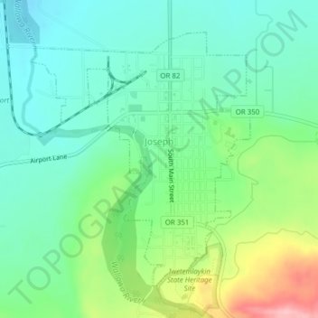
Name: Joseph topographic map, elevation, terrain.

Location: Joseph, Wallowa County, Oregon, 97846, United States (45.33959 -117.24665 45.36118 -117.22024)

Average elevation: 4,216 ft

Minimum elevation: 4,052 ft

Maximum elevation: 4,606 ft

Wallowa County trails, hiking, mountain biking, running and outdoor activities

Other topographic maps

Click on a map to view its topography, its elevation and its terrain.

Joseph

United States > Oregon > Wallowa County

Average elevation: 4,213 ft

Imnaha

United States > Oregon > Wallowa County

Average elevation: 2,825 ft

Blue Lake

United States > Oregon > Wallowa County

Average elevation: 7,726 ft

Joseph

United States > Oregon > Wallowa County

Average elevation: 4,213 ft

Barton Heights

United States > Oregon > Wallowa County

Average elevation: 4,386 ft

Gear up for your next adventure:

🌧️Backpack Rain Cover - Keep gear dry in wet weather
📌Outdoor GPS Map App - Apps and devices for digital topographic navigation
🪶Fire Starter Kit - Reliable fire starter for survival and camping
🪶Camping Sleeping Pad - Comfortable sleeping pad for backpacking
📱Solar Portable Charger - Solar power bank for charging devices off‑grid

As an Amazon Associate, this site earns from qualifying purchases at no extra cost to you.