
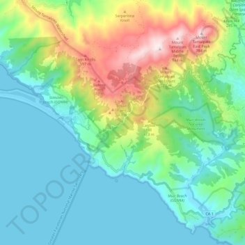
Mount Tamalpais State Park topographic map
Interactive map
Click on the map to display elevation.
About this map
Name: Mount Tamalpais State Park topographic map, elevation, terrain.
Average elevation: 676 ft
Minimum elevation: -7 ft
Maximum elevation: 2,552 ft
Marin County trails, hiking, mountain biking, running and outdoor activities
Other topographic maps
Click on a map to view its topography, its elevation and its terrain.
San Quentin
United States > California > Marin County
San Quentin (Spanish: San Quintín, meaning "St. Quentin") is a small unincorporated community in Marin County, California, United States. It is located west of Point San Quentin, at an elevation of 30 feet (9.1 meters).
Average elevation: 10 ft
Golden Gate National Recreation Area
United States > California > Marin County
Average elevation: 492 ft
Cascade Canyon Open Space Preserve
United States > California > Marin County > Fairfax > Manor
Average elevation: 627 ft
San Anselmo
United States > California > Marin County
San Anselmo (Spanish for '"Saint Anselm"') is an incorporated town in Marin County, California, United States. San Anselmo is located 1.5 miles (2.4 km) west of San Rafael, at an elevation of 46 feet (14 m). It is located about 20 miles (32 km) north of San Francisco. The town is bordered by San Rafael to the…
Average elevation: 325 ft
San Geronimo
United States > California > Marin County
San Geronimo (Spanish: San Gerónimo, meaning "St. Jerome") is a census-designated place (CDP) located in the San Geronimo Valley in Marin County, California in the United States. San Geronimo is located with Lagunitas-Forest Knolls to its west, Woodacre to its east, and 8 miles (13 km) southwest of downtown…
Average elevation: 768 ft
Baltimore Park
United States > California > Marin County > Larkspur > Larkspur > Baltimore Park
Average elevation: 190 ft