Geolocate

Yantis topographic map

Click on the map to display elevation.

About this map

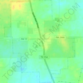
Name: Yantis topographic map, elevation, terrain.

Location: Yantis, Wood County, Texas, United States (32.91633 -95.58947 32.94304 -95.56114)

Average elevation: 476 ft

Minimum elevation: 440 ft

Maximum elevation: 522 ft

Wood County trails, hiking, mountain biking, running and outdoor activities

Other topographic maps

Click on a map to view its topography, its elevation and its terrain.

Concord

United States > Texas > Wood County

Average elevation: 420 ft

Holly Lake Ranch

United States > Texas > Wood County

Average elevation: 400 ft

Angler

United States > Texas > Wood County

Average elevation: 331 ft

Calvary

United States > Texas > Wood County

Average elevation: 433 ft

Gear up for your next adventure:

📚USA Hiking Guide Books - Top trail guides and map books
👓Polarized Sunglasses - Outdoor sunglasses for glare reduction
🕶️Glacier Sunglasses - Side shields to protect eyes from high-altitude snow glare
🔭Telescopic Hiking Pole - Adjustable pole for hiking stability
🔪Outdoor Multitools - Essential survival tools for gear repair and field use

As an Amazon Associate, this site earns from qualifying purchases at no extra cost to you.