
木吉乡 topographic map
Interactive map
Click on the map to display elevation.
About this map
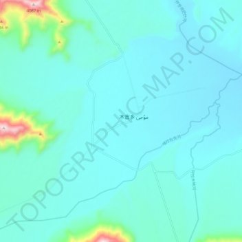
Name: 木吉乡 topographic map, elevation, terrain.
Location: 木吉乡, 阿克陶县, 克孜勒苏柯尔克孜自治州, 新疆维吾尔自治区, 中国 (38.96222 74.38927 39.04222 74.46927)
Average elevation: 11,575 ft
Minimum elevation: 11,342 ft
Maximum elevation: 13,337 ft
木吉乡属高原高寒气候,平均海拔3 700米,生产生活区海拔3 500~4 500米。境内有木吉河及其支流喀拉足克河,汇入盖孜河;以及玛尔坎苏河,汇入克孜勒苏河。
Other topographic maps
Click on a map to view its topography, its elevation and its terrain.