Geolocate

Caher topographic map

Click on the map to display elevation.

About this map

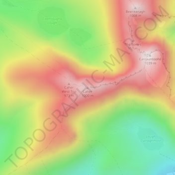
Name: Caher topographic map, elevation, terrain.

Location: Caher, Kenmare Municipal District, County Kerry, Munster, V93 A8N1, Ireland (51.99439 -9.75844 51.99449 -9.75834)

Average elevation: 2,024 ft

Minimum elevation: 620 ft

Maximum elevation: 3,337 ft

Other topographic maps

Click on a map to view its topography, its elevation and its terrain.

Great Skellig

Ireland > County Kerry

Skellig Michael consists of approximately 22 hectares (54 acres) of rock, with its highest point, known as the Spit, 218 m (714 ft) above sea level. The island is defined by its twin peaks and intervening valley (known as Christ's Saddle), which make its landscape steep and inhospitable. It is best known for…

Average elevation: 3 ft

Tralee Municipal District

Ireland > County Kerry

Average elevation: 364 ft

Brick

Ireland > County Kerry

Average elevation: 16 ft

Kenmare Municipal District

Ireland > County Kerry

Average elevation: 322 ft

Brick

Ireland > County Kerry

Average elevation: 16 ft

Tralee

Ireland > County Kerry > Tralee

Average elevation: 66 ft

Gear up for your next adventure:

🎒Trekking Poles - Sturdy poles for balance and stability on rough terrain
🧥Men's Rain Shells - Premium waterproof and breathable jackets for mountain weather
🌎3D Topographic Globes - Raised relief globes for a tactile understanding of geography
🧤Hiking Gloves - Protective gloves for rugged trails
💧Water Purification System - Clean water on the trail with reliable purifiers

As an Amazon Associate, this site earns from qualifying purchases at no extra cost to you.