Geolocate

Presquile National Wildlife Refuge topographic map

Interactive map

Click on the map to display elevation.

About this map

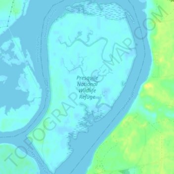
Name: Presquile National Wildlife Refuge topographic map, elevation, terrain.

Location: Presquile National Wildlife Refuge, Chesterfield County, Virginia, United States (37.34637 -77.27300 37.37977 -77.24614)

Average elevation: 13 ft

Minimum elevation: -3 ft

Maximum elevation: 69 ft

Chesterfield County trails, hiking, mountain biking, running and outdoor activities

Other topographic maps

Click on a map to view its topography, its elevation and its terrain.

Beach

United States > Virginia > Chesterfield County

Average elevation: 253 ft

Woodlake

United States > Virginia > Chesterfield County

Average elevation: 220 ft

Summerford

United States > Virginia > Chesterfield County

Average elevation: 285 ft

Leader

United States > Virginia > Chesterfield County

Average elevation: 262 ft

Midlothian

United States > Virginia > Chesterfield County

Average elevation: 318 ft

Five Forks

United States > Virginia > Chesterfield County

Average elevation: 233 ft

Nash Grove

United States > Virginia > Chesterfield County

Average elevation: 256 ft

Brandermill

United States > Virginia > Chesterfield County

Average elevation: 236 ft