
Make a donation
Gear up for your next adventure:
As an Amazon Associate, this site earns from qualifying purchases at no extra cost to you.
Woodlake topographic map
Click on the map to display elevation.
Make a donation
Gear up for your next adventure:
As an Amazon Associate, this site earns from qualifying purchases at no extra cost to you.
About this map
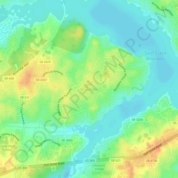
Name: Woodlake topographic map, elevation, terrain.
Average elevation: 220 ft
Minimum elevation: 167 ft
Maximum elevation: 302 ft
Chesterfield County trails, hiking, mountain biking, running and outdoor activities
Make a donation
Gear up for your next adventure:
As an Amazon Associate, this site earns from qualifying purchases at no extra cost to you.
Other topographic maps
Click on a map to view its topography, its elevation and its terrain.
Bon Air
United States > Virginia > Chesterfield County > Bon Air
In the 19th century, it was believed that the higher elevation and distance from the urban area of Richmond provided a more healthful atmosphere, particularly in the hot summer months in central Virginia. With its nearby location and greater elevation, Bon Air offered these features nearby, and was founded as…
Average elevation: 285 ft
Robious Landing Park
United States > Virginia > Chesterfield County > Midlothian
Average elevation: 180 ft
Make a donation
Gear up for your next adventure:
As an Amazon Associate, this site earns from qualifying purchases at no extra cost to you.
Presquile National Wildlife Refuge
United States > Virginia > Chesterfield County
Average elevation: 13 ft