Geolocate

Apahida topographic map

Click on the map to display elevation.

About this map

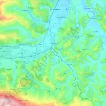
Name: Apahida topographic map, elevation, terrain.

Location: Apahida, Cluj Metropolitan Area, Cluj, Romania (46.70520 23.62132 46.86839 23.85889)

Average elevation: 1,260 ft

Minimum elevation: 932 ft

Maximum elevation: 2,493 ft

Other topographic maps

Click on a map to view its topography, its elevation and its terrain.

Cojocna

Romania > Cluj

Average elevation: 1,201 ft

Apuseni Mountains

Romania > Cluj > Valea Ierii

Average elevation: 5,299 ft

Mera

Romania > Cluj

Average elevation: 1,562 ft

Rogojel

Romania > Cluj

Average elevation: 2,933 ft

Rotunda

Romania > Cluj

Average elevation: 1,385 ft

Gilău

Romania > Cluj

Average elevation: 1,434 ft

Rădaia

Romania > Cluj

Average elevation: 1,522 ft

Mărișel

Romania > Cluj

Average elevation: 3,776 ft

Muntele Rece

Romania > Cluj > Muntele Rece

Average elevation: 3,199 ft

Gear up for your next adventure:

🧦Hiking Socks - Comfortable socks to prevent blisters on long hikes
🦶Carbon Trekking Poles - Reduce knee impact on steep descents with ultra-light poles
Backpacking Tent - Lightweight and durable tent for multi‑day hikes
🧤Tactile Hiking Gloves - Keep hands warm while operating GPS and smartphone screens
🏥Hiking First Aid Kits - Comprehensive medical kits for remote trail injuries

As an Amazon Associate, this site earns from qualifying purchases at no extra cost to you.