
Alto topographic map
Click on the map to display elevation.
Alto
Alto is located at an elevation of 7,550 feet (2,300 m) in the Lincoln National Forest, five miles (8.0 km) north of the village of Ruidoso. Alto received its name from the Spanish word "high" because of its elevation.
About this map
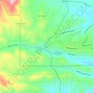
Name: Alto topographic map, elevation, terrain.
Location: Alto, Lincoln County, New Mexico, 88312, United States (33.37907 -105.69993 33.41907 -105.65993)
Average elevation: 7,497 ft
Minimum elevation: 7,126 ft
Maximum elevation: 8,251 ft
Lincoln County trails, hiking, mountain biking, running and outdoor activities
Other topographic maps
Click on a map to view its topography, its elevation and its terrain.
Ruidoso
United States > New Mexico > Lincoln County
Ruidoso is in southern Lincoln County, with elevations ranging from 6,400 feet (2,000 m) at the village's southeast corner in the valley of the Rio Ruidoso up to over 7,700 feet (2,300 m) at the village's northern end near Alto. Ruidoso's southern border and westernmost border follow the Otero County line. The…
Average elevation: 7,503 ft
Capitan
United States > New Mexico > Lincoln County
Capitan is a village in Lincoln County, New Mexico, United States, located north of the Lincoln National Forest between the Capitan and Sacramento Mountains at an elevation of 6,350 feet (1,950 m). The population was 1,489 at the 2010 census. Capitan was founded in the 1890s and incorporated in 1941.
Average elevation: 6,516 ft
Carrizozo
United States > New Mexico > Lincoln County
To the west of the town is the Carrizozo Malpais, a 40-mile-long (64 km) lava flow that is about 1,500 years old and accessible through the Valley of Fires Recreation Area. To the northeast is Carrizo Mountain, a 9,600-foot (2,900 m) peak within the Sacramento Mountains, and to the southeast is the Sierra…
Average elevation: 5,456 ft
Ruidoso
United States > New Mexico > Lincoln County
Ruidoso is in southern Lincoln County, with elevations ranging from 6,400 feet (2,000 m) at the village's southeast corner in the valley of the Rio Ruidoso up to over 7,700 feet (2,300 m) at the village's northern end near Alto. Ruidoso's southern border and westernmost border follow the Otero County line. The…
Average elevation: 7,503 ft
Capitan
United States > New Mexico > Lincoln County
Capitan is a village in Lincoln County, New Mexico, United States, located north of the Lincoln National Forest between the Capitan and Sacramento Mountains at an elevation of 6,350 feet (1,950 m). The population was 1,489 at the 2010 census. Capitan was founded in the 1890s and incorporated in 1941.
Average elevation: 6,516 ft