
Make a donation
Gear up for your next adventure:
As an Amazon Associate, this site earns from qualifying purchases at no extra cost to you.
Sa Pa topographic map
Click on the map to display elevation.
Make a donation
Gear up for your next adventure:
As an Amazon Associate, this site earns from qualifying purchases at no extra cost to you.
Sa Pa
Sa Pa District is in Lào Cai Province, northwest Vietnam, 380 km northwest of Hanoi close to the border with China. The Hoàng Liên Sơn range of mountains dominates the district, which is at the eastern extremity of the Himalayas. This range includes Vietnam's highest mountain, Fan Si Pan, at a height of 3143 m above sea level. In addition, other mountains like Aurora & J (where the sun appears at sunrise) complete a very steep terrain. The town of Sa Pa lies at an average elevation of about 1,600 m (5,200 ft). The climate is moderate and rainy in summer (May—August), and foggy and cold with occasional snowfalls in winter.
Make a donation
Gear up for your next adventure:
As an Amazon Associate, this site earns from qualifying purchases at no extra cost to you.
About this map
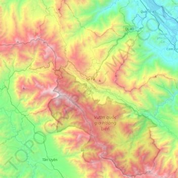
Name: Sa Pa topographic map, elevation, terrain.
Location: Sa Pa, Lào Cai Province, 33000, Vietnam (22.13742 103.72865 22.49334 104.08359)
Average elevation: 4,157 ft
Minimum elevation: 230 ft
Maximum elevation: 10,167 ft
Make a donation
Gear up for your next adventure:
As an Amazon Associate, this site earns from qualifying purchases at no extra cost to you.
Other topographic maps
Click on a map to view its topography, its elevation and its terrain.
Sa Pa
Vietnam > Lao Cai province > Sa Pa
Sa Pa District is in Lào Cai Province, northwest Vietnam, 380 km northwest of Hanoi close to the border with China. The Hoàng Liên Son range of mountains dominates the district, which is at the eastern extremity of the Himalayas. This range includes Vietnam's highest mountain, Fan Si Pan, at a height of…
Average elevation: 4,987 ft
Fansipan Mountain
Vietnam > Lao Cai province > Tân Uyên District > Sa Pa
Fansipan is the tallest mountain in the Hoang Lien Son Range, situated on the border of Hải Châu Province and Lai Châu Province with its peak located on the Lào Cai side. The mountain is part of the Hoàng Liên National Park. It has a topographic prominence of 1,613 metres (5,292 ft), ranking 6th in Vietnam.
Average elevation: 8,583 ft
Make a donation
Gear up for your next adventure:
As an Amazon Associate, this site earns from qualifying purchases at no extra cost to you.
Make a donation
Gear up for your next adventure:
As an Amazon Associate, this site earns from qualifying purchases at no extra cost to you.
Fansipan Mountain
Vietnam > Lao Cai province > Sa Pa > Xã Hoàng Liên
Fansipan is the tallest mountain in the Hoang Lien Son Range, situated on the border of Lào Cai Province and Lai Châu Province with its peak located on the Lào Cai side. The mountain is part of the Hoàng Liên National Park. It has a topographic prominence of 1,613 metres (5,292 ft), ranking 6th in Vietnam.
Average elevation: 8,583 ft
Make a donation
Gear up for your next adventure:
As an Amazon Associate, this site earns from qualifying purchases at no extra cost to you.