
Make a donation
Gear up for your next adventure:
As an Amazon Associate, this site earns from qualifying purchases at no extra cost to you.
Kannamangala topographic map
Click on the map to display elevation.
Make a donation
Gear up for your next adventure:
As an Amazon Associate, this site earns from qualifying purchases at no extra cost to you.
About this map
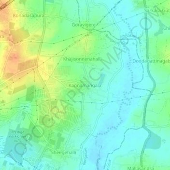
Name: Kannamangala topographic map, elevation, terrain.
Average elevation: 2,851 ft
Minimum elevation: 2,808 ft
Maximum elevation: 2,933 ft
Make a donation
Gear up for your next adventure:
As an Amazon Associate, this site earns from qualifying purchases at no extra cost to you.
Other topographic maps
Click on a map to view its topography, its elevation and its terrain.
Halanayakanahalli Lake
India > Karnataka > Bangalore East > Chikkanayakanahalli
Average elevation: 2,940 ft
Make a donation
Gear up for your next adventure:
As an Amazon Associate, this site earns from qualifying purchases at no extra cost to you.
Lal Bahadur Shastri Nagar Lake
India > Karnataka > Bangalore East > Bengaluru
Average elevation: 2,917 ft