Geolocate

Ullin topographic map

Click on the map to display elevation.

About this map

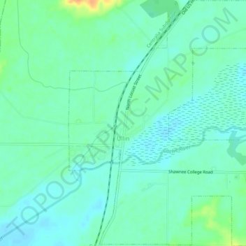
Name: Ullin topographic map, elevation, terrain.

Location: Ullin, Pulaski County, Illinois, 62992, United States (37.26106 -89.19354 37.29734 -89.15528)

Average elevation: 341 ft

Minimum elevation: 308 ft

Maximum elevation: 427 ft

Pulaski County trails, hiking, mountain biking, running and outdoor activities

Other topographic maps

Click on a map to view its topography, its elevation and its terrain.

Wetaug

United States > Illinois > Pulaski County

Average elevation: 381 ft

Gear up for your next adventure:

🧣Merino Neck Gaiters - Multi-functional headwear for wind and sun protection
🥤Water Filter Bottle - All‑in‑one filter bottle for safe hydration
🔊Portable Camp Speaker - Music and alerts at camp
🚗GPS Dash Cams - Record your scenic drives through mountain passes and canyons
🧦Hiking Socks - Comfortable socks to prevent blisters on long hikes

As an Amazon Associate, this site earns from qualifying purchases at no extra cost to you.