Geolocate

Wetaug topographic map

Click on the map to display elevation.

About this map

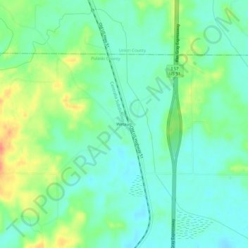
Name: Wetaug topographic map, elevation, terrain.

Location: Wetaug, Pulaski County, Illinois, 62992, United States (37.30394 -89.18674 37.34394 -89.14674)

Average elevation: 381 ft

Minimum elevation: 325 ft

Maximum elevation: 499 ft

Pulaski County trails, hiking, mountain biking, running and outdoor activities

Other topographic maps

Click on a map to view its topography, its elevation and its terrain.

Ullin

United States > Illinois > Pulaski County

Average elevation: 341 ft

Mounds

United States > Illinois > Pulaski County

Average elevation: 338 ft

New Grand Chain

United States > Illinois > Pulaski County

Average elevation: 390 ft

Mound City

United States > Illinois > Pulaski County

Average elevation: 312 ft

Gear up for your next adventure:

🎒Day Hiking Backpack - Lightweight backpack perfect for day trips and outdoor adventures
💧Water Filtration Bottles - Safely drink from streams and lakes while exploring
🔌USB Car Charger - Car charger for on‑the‑go power needs
🥾Women's Hiking Boots - Top-rated trail boots with ankle support and superior grip
🚗GPS Dash Cams - Record your scenic drives through mountain passes and canyons

As an Amazon Associate, this site earns from qualifying purchases at no extra cost to you.