Hermosa topographic map
Interactive map
Click on the map to display elevation.
About this map
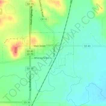
Name: Hermosa topographic map, elevation, terrain.
Location: Hermosa, Custer County, South Dakota, United States (43.83246 -103.20446 43.84320 -103.18414)
Average elevation: 3,314 ft
Minimum elevation: 3,255 ft
Maximum elevation: 3,435 ft
Other topographic maps
Click on a map to view its topography, its elevation and its terrain.
Stockade Lake
United States > South Dakota > Custer County
Stockade Lake, Custer County, South Dakota, United States
Average elevation: 5,302 ft
Custer State Park
United States > South Dakota > Custer County
Custer State Park, Custer County, South Dakota, United States
Average elevation: 4,636 ft
Spokane
United States > South Dakota > Custer County
Spokane, Custer County, South Dakota, United States
Average elevation: 4,573 ft
Fourmile
United States > South Dakota > Custer County
Fourmile, Custer County, South Dakota, United States
Average elevation: 5,476 ft
Sylvan Lake Resort
United States > South Dakota > Custer County
Sylvan Lake Resort, Custer County, South Dakota, United States
Average elevation: 6,198 ft
State Game Lodge
United States > South Dakota > Custer County
State Game Lodge, Custer County, South Dakota, United States
Average elevation: 4,423 ft
Berne
United States > South Dakota > Custer County
Berne, Custer County, South Dakota, United States
Average elevation: 5,902 ft
Buffalo Gap
United States > South Dakota > Custer County
Buffalo Gap, Custer County, South Dakota, 57722, United States
Average elevation: 3,297 ft
Wind Cave National Park
United States > South Dakota > Custer County
Wind Cave National Park, Custer County, South Dakota, United States
Average elevation: 4,314 ft