Geolocate

Spokane topographic map

Click on the map to display elevation.

About this map

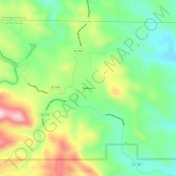
Name: Spokane topographic map, elevation, terrain.

Location: Spokane, Custer County, South Dakota, United States (43.82138 -103.39991 43.86138 -103.35991)

Average elevation: 4,573 ft

Minimum elevation: 4,101 ft

Maximum elevation: 5,335 ft

Custer County trails, hiking, mountain biking, running and outdoor activities

Other topographic maps

Click on a map to view its topography, its elevation and its terrain.

Pringle

United States > South Dakota > Custer County

Average elevation: 4,980 ft

Hermosa

United States > South Dakota > Custer County

Average elevation: 3,337 ft

Lakota Lake

United States > South Dakota > Custer County

Average elevation: 4,623 ft

Gear up for your next adventure:

🏫Relief Map Kits - Hands-on tools for teaching landforms and elevation
📚Navigation Handbooks - Master the art of reading topographic maps and using a compass
💧Water Filtration Bottles - Safely drink from streams and lakes while exploring
🎒Trekking Poles - Sturdy poles for balance and stability on rough terrain
🪶LED Camping Lantern - Bright lantern for camp lighting

As an Amazon Associate, this site earns from qualifying purchases at no extra cost to you.