Geolocate

Kuchlak topographic map

Click on the map to display elevation.

About this map

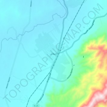
Name: Kuchlak topographic map, elevation, terrain.

Location: Kuchlak, Balochistan, Pakistan (30.32282 66.90968 30.40282 66.98968)

Average elevation: 5,400 ft

Minimum elevation: 4,993 ft

Maximum elevation: 7,946 ft

Other topographic maps

Click on a map to view its topography, its elevation and its terrain.

Chagai District

Pakistan > Balochistan

Average elevation: 3,015 ft

Quetta City Tehsil

Pakistan > Balochistan > Quetta District

Average elevation: 6,499 ft

Quetta District

Pakistan > Balochistan

Average elevation: 5,072 ft

Hanna Lake

Pakistan > Balochistan > Quetta

Average elevation: 6,421 ft

Khuzdar Tehsil

Pakistan > Balochistan > Khuzdar District

Average elevation: 3,232 ft

Ziarat Park

Pakistan > Balochistan > Quetta

Average elevation: 5,505 ft

Gear up for your next adventure:

🪶Survival Guide Book - Expert advice for emergency preparedness
🏔️Mountain Trail Maps - High‑detail maps for popular peaks
🌄Hiking Binoculars - Compact binoculars for scenic views and trail spotting
⛑️Personal Locator Beacon - Safety beacon for emergencies
😴Insulated Sleeping Pads - Compact and warm pads for high-elevation camping

As an Amazon Associate, this site earns from qualifying purchases at no extra cost to you.