Geolocate

Quetta District topographic map

Click on the map to display elevation.

About this map

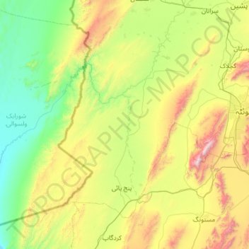
Name: Quetta District topographic map, elevation, terrain.

Location: Quetta District, Quetta Division, Balochistan, Pakistan (29.80350 66.22893 30.48662 67.28604)

Average elevation: 5,072 ft

Minimum elevation: 3,150 ft

Maximum elevation: 10,663 ft

Other topographic maps

Click on a map to view its topography, its elevation and its terrain.

Panjgur

Pakistan > Balochistan > Panjgur District

Average elevation: 3,228 ft

Sibi

Pakistan > Balochistan > Sibi District

Average elevation: 558 ft

Jhal Magsi

Pakistan > Balochistan > Jhal Magsi District

Average elevation: 220 ft

Mud Volcano

Pakistan > Balochistan > Gwadar District

Average elevation: 39 ft

Khuzdar

Pakistan > Balochistan > Khuzdar District

Khuzdar is at the apex of a narrow valley at an elevation of 1,237 metres (4,058 ft). Despite this altitude, Khuzdar like most of Balochistan has an arid climate (Köppen BWh) with very low and erratic rainfall. Unlike most parts of the province, the heaviest average rainfall comes from the Asian monsoon in…

Average elevation: 4,649 ft

Isa

Pakistan > Balochistan

Average elevation: 16 ft

Hub

Pakistan > Balochistan > Hub

Average elevation: 180 ft

Ziarat Park

Pakistan > Balochistan > Quetta

Average elevation: 5,505 ft

Kuchlak

Pakistan > Balochistan

Average elevation: 5,400 ft

Chatta

Pakistan > Balochistan

Average elevation: 226 ft

Gear up for your next adventure:

🦺Reflective Outdoor Gear - Safety gear for low‑light conditions
🥇GPS Hiking Watch - Multi‑sport GPS watch with navigation and trail tracking
🪑Portable Camp Table - Compact table for campsite meals
📚USA Hiking Guide Books - Top trail guides and map books
🧺Microfiber Travel Towels - Compact and fast-drying towels for trail use

As an Amazon Associate, this site earns from qualifying purchases at no extra cost to you.