
Make a donation
Gear up for your next adventure:
As an Amazon Associate, this site earns from qualifying purchases at no extra cost to you.
Salisbury topographic map
Click on the map to display elevation.
Make a donation
Gear up for your next adventure:
As an Amazon Associate, this site earns from qualifying purchases at no extra cost to you.
Salisbury
According to the U.S. Census Bureau, the township has a total area of 11.3 square miles (29.2 km2), of which 11.2 square miles (28.9 km2) are land and 0.1 square miles (0.3 km2), or 0.87%, are water. It is drained by the Lehigh River, which separates it from Bethlehem and the east side of Allentown, and borders Upper Saucon Township on South Mountain. Elevations range from approximately 220 feet (67 m) above sea level on the river to 1,030 feet (310 m) in Big Rock County Park.
Make a donation
Gear up for your next adventure:
As an Amazon Associate, this site earns from qualifying purchases at no extra cost to you.
About this map
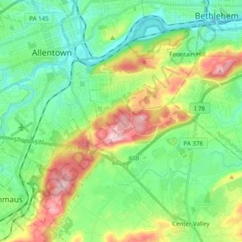
Name: Salisbury topographic map, elevation, terrain.
Location: Salisbury, Lehigh County, Pennsylvania, United States (40.52913 -75.53005 40.61699 -75.39429)
Average elevation: 469 ft
Minimum elevation: 207 ft
Maximum elevation: 1,037 ft
Lehigh County trails, hiking, mountain biking, running and outdoor activities
Make a donation
Gear up for your next adventure:
As an Amazon Associate, this site earns from qualifying purchases at no extra cost to you.
Other topographic maps
Click on a map to view its topography, its elevation and its terrain.
Hensingersville
United States > Pennsylvania > Lehigh County > Lower Macungie Township
Average elevation: 666 ft
Bake Oven Knob
United States > Pennsylvania > Lehigh County > Heidelberg Township
Average elevation: 1,017 ft
Walbert
United States > Pennsylvania > Lehigh County > South Whitehall Township
Average elevation: 449 ft
Make a donation
Gear up for your next adventure:
As an Amazon Associate, this site earns from qualifying purchases at no extra cost to you.
Old Zionsville
United States > Pennsylvania > Lehigh County > Upper Milford Township
Average elevation: 712 ft
Laurys Station
United States > Pennsylvania > Lehigh County > North Whitehall Township
Average elevation: 499 ft
Neffs
United States > Pennsylvania > Lehigh County > North Whitehall Township
Average elevation: 682 ft
Make a donation
Gear up for your next adventure:
As an Amazon Associate, this site earns from qualifying purchases at no extra cost to you.
Crackersport
United States > Pennsylvania > Lehigh County > South Whitehall Township
Average elevation: 453 ft
Metamora Station
United States > Pennsylvania > Lehigh County > South Whitehall Township > Metamora Station
Average elevation: 410 ft
Milford Park
United States > Pennsylvania > Lehigh County > Upper Milford Township
Average elevation: 725 ft
Make a donation
Gear up for your next adventure:
As an Amazon Associate, this site earns from qualifying purchases at no extra cost to you.