
Montvale topographic map
Click on the map to display elevation.
Montvale
Montvale was incorporated as a borough on August 31, 1894, from portions of Orvil Township and Washington Township. The borough was formed during the "Boroughitis" phenomenon then sweeping through Bergen County, in which 26 boroughs were formed in the county in 1894 alone. On February 15, 1896, Montvale acquired part of Orvil Township. In 1906, Montvale added further land from Orvil and Washington townships, and in 1912, Montvale added territory from Upper Saddle River. On May 20, 1959, portions of Montvale were passed to River Vale, and on December 9 and 14, 1965, territories were exchanged between Montvale and Upper Saddle River. The borough's name is derived from its topography.
About this map
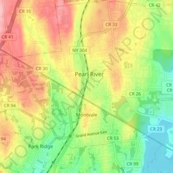
Name: Montvale topographic map, elevation, terrain.
Location: Montvale, Bergen County, New Jersey, 07645, United States (41.03701 -74.07937 41.07284 -74.01245)
Average elevation: 256 ft
Minimum elevation: 46 ft
Maximum elevation: 482 ft
Bergen County trails, hiking, mountain biking, running and outdoor activities
Other topographic maps
Click on a map to view its topography, its elevation and its terrain.
Hillsdale
United States > New Jersey > Bergen County > Hillsdale > Hillsdale
Average elevation: 131 ft
Ferdinands Mills
United States > New Jersey > Bergen County > Franklin Lakes
Average elevation: 423 ft
Ridgefield Park
United States > New Jersey > Bergen County > Ridgefield Park > Ridgefield Park
Average elevation: 69 ft
Glen Rock
United States > New Jersey > Bergen County > Glen Rock > Glen Rock
Average elevation: 171 ft