
Nazko topographic map
Click on the map to display elevation.
About this map
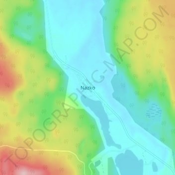
Name: Nazko topographic map, elevation, terrain.
Average elevation: 2,923 ft
Minimum elevation: 2,726 ft
Maximum elevation: 3,379 ft
Other topographic maps
Click on a map to view its topography, its elevation and its terrain.
Area I (West Fraser/Nazko)
Canada > British Columbia > Cariboo Regional District > Area I (West Fraser/Nazko)
Average elevation: 3,701 ft
Titetown Lake
Canada > British Columbia > Cariboo Regional District > Area I (West Fraser/Nazko)
Average elevation: 2,835 ft