
Make a donation
Gear up for your next adventure:
As an Amazon Associate, this site earns from qualifying purchases at no extra cost to you.
Friolzheim topographic map
Click on the map to display elevation.
Make a donation
Gear up for your next adventure:
As an Amazon Associate, this site earns from qualifying purchases at no extra cost to you.
Friolzheim
Höhepunkt eines jeden Jahres ist der am Pfingstmontag stattfindende Pfingstmarkt. Ursprünglich als Tier- und Krämermarkt eingeführt, ist er heute Anziehungspunkt für Zehntausende, die die Vielzahl an bunten Marktständen oder die Fahrgeschäfte auf dem Marktplatz besuchen und das Treiben zu einer „Hocketse“ an einer der vielen Verköstigungsstationen nutzen. Am ersten Advent findet traditionell der Weihnachtsbasar statt, ein Markt mit überwiegend selbst gebastelten Weihnachts- und Winterutensilien. Ende Februar wird mit dem Wintermarkt die kalte Jahreszeit verabschiedet.
Make a donation
Gear up for your next adventure:
As an Amazon Associate, this site earns from qualifying purchases at no extra cost to you.
About this map
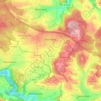
Name: Friolzheim topographic map, elevation, terrain.
Average elevation: 1,447 ft
Minimum elevation: 1,148 ft
Maximum elevation: 1,680 ft
Make a donation
Gear up for your next adventure:
As an Amazon Associate, this site earns from qualifying purchases at no extra cost to you.
Other topographic maps
Click on a map to view its topography, its elevation and its terrain.
Stein
Deutschland > Baden-Württemberg > Enzkreis
Königsbach-Stein liegt etwa zwölf Kilometer nordwestlich der Kreisstadt Pforzheim und etwa 20 km östlich von Karlsruhe zwischen Kraichgau und Nordschwarzwald in 177 bis 330 Metern Höhe.
Average elevation: 791 ft
Make a donation
Gear up for your next adventure:
As an Amazon Associate, this site earns from qualifying purchases at no extra cost to you.
Make a donation
Gear up for your next adventure:
As an Amazon Associate, this site earns from qualifying purchases at no extra cost to you.
Make a donation
Gear up for your next adventure:
As an Amazon Associate, this site earns from qualifying purchases at no extra cost to you.
Zaisersweiher
Deutschland > Baden-Württemberg > Enzkreis > Maulbronn
Maulbronn verfügt mit dem Bahnhof Maulbronn West seit 1853 über eine ca. 3,5 km von Stadtzentrum entfernt im Wald gelegene Station an der Westbahn Bietigheim-Bissingen–Bruchsal. Diese ungünstige Bahnhofslage hat topografische Gründe. Die Westbahn erhielt einen Tunnel südlich des Bahnhofs (Name nach dem…
Average elevation: 965 ft
Make a donation
Gear up for your next adventure:
As an Amazon Associate, this site earns from qualifying purchases at no extra cost to you.
Königsbach
Deutschland > Baden-Württemberg > Enzkreis
Königsbach-Stein liegt etwa zwölf Kilometer nordwestlich der Kreisstadt Pforzheim und etwa 20 km östlich von Karlsruhe zwischen Kraichgau und Nordschwarzwald in 177 bis 330 Metern Höhe.
Average elevation: 715 ft
Make a donation
Gear up for your next adventure:
As an Amazon Associate, this site earns from qualifying purchases at no extra cost to you.
Schellbronn
Deutschland > Baden-Württemberg > Enzkreis
Die Gemeindefläche ist in Triasschichten gelegen. Aufgrund der Höhenlage zwischen Nagold- und Würmtal auf den nordöstlichen Schwarzwald-Randplatten dominiert der Obere Buntsandstein, der vereinzelt von Unterem Muschelkalk überlagert wird. Südlich grenzt an Neuhausen das Gäuland mit Unterem und Mittlerem…
Average elevation: 1,542 ft
Make a donation
Gear up for your next adventure:
As an Amazon Associate, this site earns from qualifying purchases at no extra cost to you.
Make a donation
Gear up for your next adventure:
As an Amazon Associate, this site earns from qualifying purchases at no extra cost to you.
Make a donation
Gear up for your next adventure:
As an Amazon Associate, this site earns from qualifying purchases at no extra cost to you.