Geolocate

Russell topographic map

Click on the map to display elevation.

About this map

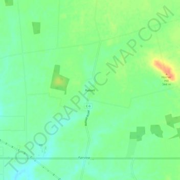
Name: Russell topographic map, elevation, terrain.

Location: Russell, Highland County, Ohio, United States (39.19951 -83.74853 39.23951 -83.70853)

Average elevation: 1,053 ft

Minimum elevation: 1,001 ft

Maximum elevation: 1,135 ft

Highland County trails, hiking, mountain biking, running and outdoor activities

Other topographic maps

Click on a map to view its topography, its elevation and its terrain.

Hillsboro

United States > Ohio > Highland County

Average elevation: 1,027 ft

Rocky Fork Lake

United States > Ohio > Highland County

Average elevation: 955 ft

Lynchburg

United States > Ohio > Highland County

Average elevation: 1,017 ft

Highland

United States > Ohio > Highland County

Average elevation: 1,070 ft

Paint Creek Lake

United States > Ohio > Highland County

Average elevation: 909 ft

Mowrystown

United States > Ohio > Highland County

Average elevation: 981 ft

Gear up for your next adventure:

🔭Telescopic Hiking Pole - Adjustable pole for hiking stability
🪶Multi‑Purpose Knife - Useful blade for camp and trail
🌐World Map Poster - Decorative world maps with topographic info
🖼️Topo Map Wall Art - Decorative topographic prints of famous peaks and regions
🏫Relief Map Kits - Hands-on tools for teaching landforms and elevation

As an Amazon Associate, this site earns from qualifying purchases at no extra cost to you.