Geolocate

Effingham topographic map

Click on the map to display elevation.

About this map

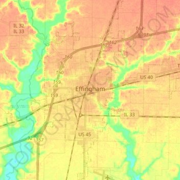
Name: Effingham topographic map, elevation, terrain.

Location: Effingham, Effingham County, Illinois, 62401, United States (39.06890 -88.60389 39.16991 -88.50455)

Average elevation: 584 ft

Minimum elevation: 499 ft

Maximum elevation: 627 ft

Effingham County trails, hiking, mountain biking, running and outdoor activities

Other topographic maps

Click on a map to view its topography, its elevation and its terrain.

Montrose

United States > Illinois > Effingham County > Montrose

Average elevation: 597 ft

Moccasin

United States > Illinois > Effingham County

Average elevation: 614 ft

Gear up for your next adventure:

🔌USB Car Charger - Car charger for on‑the‑go power needs
🦟Ultrasonic Repellers - Create a bug-free zone at your camp or rest stop
🧥Waterproof Jacket for Hiking - Breathable and rugged rain jacket for outdoor excursions
☀️Outdoor Sunscreen - High protection sunscreen for outdoor activities
Camping Coffee Makers - Enjoy premium coffee at the summit or campsite

As an Amazon Associate, this site earns from qualifying purchases at no extra cost to you.