
Hof topographic map
Click on the map to display elevation.
Hof
Hof has an humid continental climate (Köppen: Dfb; Trewartha: Dclo). Hof is located at an altitude of 565.2 metres (1,854 ft), which is much cooler than other areas in Bavaria. The average annual temperature ranges from −1 °C (30 °F) in winter to 17 °C (63 °F) in summer, and the annual precipitation is 712.6 mm (28.06 in).
About this map
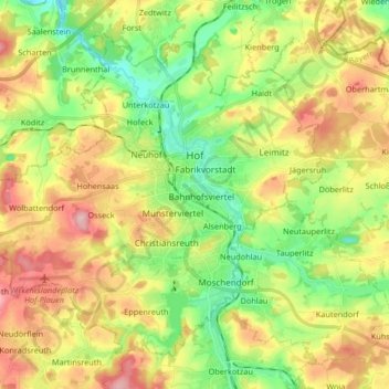
Name: Hof topographic map, elevation, terrain.
Location: Hof, Bavaria, Germany (50.26739 11.80663 50.35511 11.97185)
Average elevation: 1,742 ft
Minimum elevation: 1,499 ft
Maximum elevation: 2,057 ft
Other topographic maps
Click on a map to view its topography, its elevation and its terrain.
Zugspitze
Germany > Bavaria > Landkreis Garmisch-Partenkirchen > Grainau
The mountain rises eleven kilometres southwest of Garmisch-Partenkirchen and just under six kilometres east of Ehrwald. The border between Germany and Austria runs over the west summit; thus the Zugspitze massif belongs to the German state of Bavaria and the Austrian state of Tyrol. The municipalities…
Average elevation: 7,546 ft
Whirlpool
Germany > Bavaria > Landkreis Starnberg > Gauting > Königswiesen
Average elevation: 1,932 ft
Neuschwanstein Castle
Germany > Bavaria > Landkreis Ostallgäu > Hohenschwangau
The municipality of Schwangau lies at an elevation of 800 m (2,620 ft) at the southwest border of the German state of Bavaria. Its surroundings are characterised by the transition between the Alpine foothills in the south (toward the nearby Austrian border) and a hilly landscape in the north that appears flat…
Average elevation: 3,222 ft
Partnach Gorge
Germany > Bavaria > Landkreis Garmisch-Partenkirchen > Garmisch-Partenkirchen > Vordergraseck
Average elevation: 3,291 ft
Stockerbichl
Germany > Bavaria > Landkreis Starnberg > Tutzing > Unterzeismering
Average elevation: 2,080 ft
Lidorf
Germany > Bavaria > Landkreis Rottal-Inn > Mitterskirchen > Mitterskirchen
Average elevation: 1,503 ft
Erlangen
In 1435 the church, which had been the daughter church of St. Martin in Forchheim up until this point, was elevated to its own parish. The main task of the Erlangen priest was the pastoral care in the city of Erlangen and the St. Martin's Chapel on the Martinsbühl, which was now named for the first time.…
Average elevation: 1,086 ft
Obersalzberg
Germany > Bavaria > Landkreis Berchtesgadener Land > Berchtesgaden > Untersalzberg I
Average elevation: 3,061 ft
Neuschwanstein Castle
Germany > Bavaria > Landkreis Ostallgäu > Hohenschwangau
The municipality of Schwangau lies at an elevation of 800 m (2,620 ft) at the southwest border of the German state of Bavaria. Its surroundings are characterised by the transition between the Alpine foothills in the south (toward the nearby Austrian border) and a hilly landscape in the north that appears flat…
Average elevation: 3,222 ft
Immenstadt im Allgäu
Germany > Bavaria > Landkreis Oberallgäu > Immenstadt im Allgäu
Average elevation: 2,986 ft
Aletsberg
Germany > Bavaria > Landkreis Deggendorf > Deggendorf > Oberkandelbach
Average elevation: 1,138 ft
Zugspitze
Germany > Bavaria > Landkreis Garmisch-Partenkirchen > Grainau
The mountain rises eleven kilometres southwest of Garmisch-Partenkirchen and just under six kilometres east of Ehrwald. The border between Germany and Austria runs over the west summit; thus the Zugspitze massif belongs to the German state of Bavaria and the Austrian state of Tyrol. The municipalities…
Average elevation: 7,546 ft
Michelau i.Steigerwald
Germany > Bavaria > Landkreis Schweinfurt > Michelau i.Steigerwald
Average elevation: 1,093 ft
Bayreuth
In most places there is a signed cycle path network. In the centre of Bayreuth itself, cycling is fairly straightforward due to the relatively flat topography, something which encourages the use bicycles as an everyday means of transport. Because of the proximity of the 600 kilometre long Main Cycle Path,…
Average elevation: 1,237 ft
Wind
Germany > Bavaria > Landkreis Bamberg
Winds can shape landforms, via a variety of aeolian processes such as the formation of fertile soils, for example loess, and by erosion. Dust from large deserts can be moved great distances from its source region by the prevailing winds; winds that are accelerated by rough topography and associated with dust…
Average elevation: 932 ft
Riedlhütte
Germany > Bavaria > Landkreis Freyung-Grafenau > Sankt Oswald-Riedlhütte
Average elevation: 2,444 ft
Listsee
Germany > Bavaria > Landkreis Berchtesgadener Land > Bad Reichenhall
Average elevation: 2,615 ft
Hopfensee-Achen
Germany > Bavaria > Landkreis Ostallgäu > Füssen > Hopfen am See
Average elevation: 2,654 ft
Partnach Gorge
Germany > Bavaria > Landkreis Garmisch-Partenkirchen > Garmisch-Partenkirchen > Vordergraseck
Average elevation: 3,294 ft
5er-Grube
Germany > Bavaria > Landkreis Starnberg > Krailling > Kraillinger Innovations Meile KIM
Average elevation: 1,844 ft
Oberjettenberg
Germany > Bavaria > Landkreis Berchtesgadener Land > Schneizlreuth
Average elevation: 2,598 ft
Bad Neustadt an der Saale
Germany > Bavaria > Landkreis Rhön-Grabfeld > Bad Neustadt an der Saale
Average elevation: 938 ft
Kellmünz an der Iller
Germany > Bavaria > Landkreis Neu-Ulm > Kellmünz a.d.Iller
Average elevation: 1,844 ft
Drosendorf an der Aufseß
Germany > Bavaria > Landkreis Bayreuth > Hollfeld
Average elevation: 1,460 ft
Ruine Falkenstein
Germany > Bavaria > Landkreis Ostallgäu > Pfronten > Benken
Originally known as Castrum Pfronten, the stone castle was built approximately 1270–1280 by Count Meinhard II of Tyrol on the borders of his land. Because of the unusual situation of the castle it has been interpreted in historical context as a symbol of opposition to the Duchy of Bavaria. (During the winter…
Average elevation: 3,084 ft
Königshaus am Schachen
Germany > Bavaria > Landkreis Garmisch-Partenkirchen > Garmisch-Partenkirchen
The King's House on Schachen is located at Schachen, at an altitude with a view of the dramatic mountain backdrop of the Wetterstein Formation, about 10 km south of Garmisch-Partenkirchen, Bavaria. It can only be reached via a 10 km forest road, or a three-hour hike, ascending 1000m either from Schloss Elmau…
Average elevation: 5,344 ft
Neumühle
Germany > Bavaria > Landkreis Neustadt an der Waldnaab > Hammerles
Average elevation: 1,516 ft
Kramerspitz
Germany > Bavaria > Landkreis Garmisch-Partenkirchen > Garmisch-Partenkirchen
Average elevation: 4,718 ft
Burgstall
Germany > Bavaria > Landkreis Erlangen-Höchstadt > Herzogenaurach
Average elevation: 1,099 ft
Geroldsee (Wagenbrüchsee)
Germany > Bavaria > Landkreis Garmisch-Partenkirchen > Gerold
Average elevation: 3,412 ft
Scheuerhof
Germany > Bavaria > Landkreis Pfaffenhofen an der Ilm > Geisenfeld > Parleiten
Average elevation: 1,280 ft
Hinterkaifeck
Germany > Bavaria > Landkreis Neuburg-Schrobenhausen > Gröbern
Average elevation: 1,388 ft
Wermerichshausen
Germany > Bavaria > Landkreis Bad Kissingen > Münnerstadt
Average elevation: 1,024 ft
Heimgarten
Germany > Bavaria > Landkreis Garmisch-Partenkirchen > Ohlstadt
Heimgarten (elevation 1,790 metres/5,870 ft) is a mountain near Ohlstadt in the Bavarian Prealps of southern Germany. It is connected via a ridge with Herzogstand (1,731 metres/5,679 ft) to the east.
Average elevation: 4,403 ft