Geolocate

Mbulu topographic map

Click on the map to display elevation.

About this map

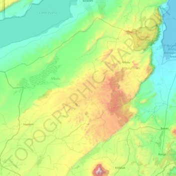
Name: Mbulu topographic map, elevation, terrain.

Location: Mbulu, Manyara Region, Northern Zone, Tanzania (-4.26804 34.89198 -3.61720 35.52522)

Average elevation: 5,036 ft

Minimum elevation: 3,363 ft

Maximum elevation: 7,930 ft

Other topographic maps

Click on a map to view its topography, its elevation and its terrain.

Kibaya

Tanzania > Manyara Region

Average elevation: 5,197 ft

Ngorika

Tanzania > Manyara Region

Average elevation: 2,313 ft

Labi

Tanzania > Manyara Region > Labay

Average elevation: 6,214 ft

Miomboni

Tanzania > Manyara Region

Average elevation: 4,577 ft

Madunga

Tanzania > Manyara Region

Average elevation: 7,103 ft

Gear up for your next adventure:

🔦LED Headlamp - Bright and durable LED headlamp for night navigation
🪵Folding Camp Saw - Compact saw for wood and campsite work
🌡️Portable Weather Meter - Track weather conditions on the trail
🥾Hiking Shoes - Durable and comfortable shoes for trail hiking
🗃️Trail First Aid Kit - Essential kit for outdoor injuries and emergencies

As an Amazon Associate, this site earns from qualifying purchases at no extra cost to you.