
Make a donation
Gear up for your next adventure:
As an Amazon Associate, this site earns from qualifying purchases at no extra cost to you.
Naters topographic map
Click on the map to display elevation.
Make a donation
Gear up for your next adventure:
As an Amazon Associate, this site earns from qualifying purchases at no extra cost to you.
About this map
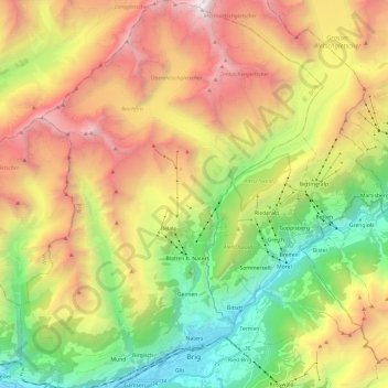
Name: Naters topographic map, elevation, terrain.
Location: Naters, Brig, Wallis, Switzerland (46.30276 7.88436 46.46917 8.06873)
Average elevation: 7,100 ft
Minimum elevation: 2,119 ft
Maximum elevation: 13,645 ft
Make a donation
Gear up for your next adventure:
As an Amazon Associate, this site earns from qualifying purchases at no extra cost to you.
Other topographic maps
Click on a map to view its topography, its elevation and its terrain.
Mund
Switzerland > Wallis > Brig
The former municipality is located in the Brig district, on the northern slope of the Rhone valley at an elevation of about 1,200 m (3,900 ft).
Average elevation: 4,101 ft