
Quetta topographic map
Click on the map to display elevation.
Quetta
Quetta (/ˈkwɛtə/; Urdu: کوئٹہ; [ˈkweːʈə] (listen); Pashto: کوټه) is the tenth most populous city in Pakistan with a population of over 1.1 million. It is situated in south-west of the country close to the International border with Afghanistan. It is the capital of the province of Balochistan where it is the largest city. Quetta is at an average elevation of 1,680 metres (5,510 feet) above sea level, making it Pakistan's only high-altitude major city. The city is known as the "Fruit Garden of Pakistan" due to the numerous fruit orchards in and around it, and the large variety of fruits and dried fruit products produced there.
About this map
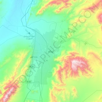
Name: Quetta topographic map, elevation, terrain.
Location: Quetta, Balochistan, 87300, Pakistan (30.03577 66.85724 30.35577 67.17724)
Average elevation: 6,457 ft
Minimum elevation: 5,046 ft
Maximum elevation: 10,433 ft
Other topographic maps
Click on a map to view its topography, its elevation and its terrain.
Gwadar
Pakistan > Balochistan > Gwadar District
Gwadar is situated on the southwestern Arabian Sea coast of Pakistan in Gwadar District of Balochistan province. Like Ormara further east, Gwadar is situated on a natural hammerhead-shaped tombolo peninsula forming two almost perfect, but naturally curved, semicircular bays on either side. The city is situated…
Average elevation: 30 ft
Qilla Abdullah District
Kila Abdullah district lies between 30 and 04' to 31–17' North Longitude in the foothills of the Shela Bagh Mountain range. It is bordered by Pishin District in the east, Quetta District in the South and by Afghanistan in the west. The geographical area of the district is 5,264 km2. It is composed of two…
Average elevation: 5,577 ft
Ziarat District
Ziarat (Urdu: ضلع زیارت) is a district in the north of Balochistan province of Pakistan. Ziarat town (situated at an altitude of about 2,400 meters) is the headquarters of the district, the sub-division, and also of the tehsil. The highest peak of Khalifat Hills, at an altitude of 11,400 feet (3,500…
Average elevation: 6,027 ft
Barkhan District
The landscape of Barkhan consists of plains, valleys and mountains varying in ground elevation ranging from 841 to 2,031 meters above Mean Sea Level (MSL). The district consists of one main valley, called Barkhan, and several smaller valleys, which are separated from the main valley by low ranges of hills…
Average elevation: 3,599 ft
Usta Muhammad Tehsil
Pakistan > Balochistan > Jafarabad District
Usta Mohammad is in the Kachhi plain basin, with an average altitude of about 55 meters. Annual rainfall is about 90mm, of which 60mm falls in winter (November–May). Winters are cold, and summers are dry and hot.
Average elevation: 174 ft
Panjgur District
Panjgur District covers an area of 16,891 square kilometres (6,522 sq mi) in western Balochistan, sharing an international border with Sistan and Baluchestan province of Iran to the west. This boundary, known as the Goldsmid Line, was formalised as the Perso-Baloch frontier in the nineteenth century and…
Average elevation: 2,812 ft
Sherani District
Many wild plants in the area are used by local communities for traditional medicine, food, animal fodder, fencing, and household needs. At higher elevations, forested areas also include Pinus gerardiana (chilghoza pine), which is valued for its edible nuts and local importance.
Average elevation: 4,304 ft