
Make a donation
Gear up for your next adventure:
As an Amazon Associate, this site earns from qualifying purchases at no extra cost to you.
Cossombrato topographic map
Click on the map to display elevation.
Make a donation
Gear up for your next adventure:
As an Amazon Associate, this site earns from qualifying purchases at no extra cost to you.
About this map
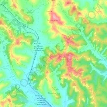
Name: Cossombrato topographic map, elevation, terrain.
Location: Cossombrato, Asti, Piemonte, Italia (44.96128 8.11981 45.00192 8.15957)
Average elevation: 696 ft
Minimum elevation: 509 ft
Maximum elevation: 991 ft
Make a donation
Gear up for your next adventure:
As an Amazon Associate, this site earns from qualifying purchases at no extra cost to you.
Other topographic maps
Click on a map to view its topography, its elevation and its terrain.
Make a donation
Gear up for your next adventure:
As an Amazon Associate, this site earns from qualifying purchases at no extra cost to you.
Zucchetto
Italia > Piemonte > Asti > Montegrosso d'Asti > Santo Stefano Canetto > Zucchetto
Average elevation: 738 ft