
赤泥坪村 topographic map
Interactive map
Click on the map to display elevation.
About this map
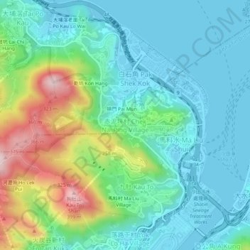
Name: 赤泥坪村 topographic map, elevation, terrain.
Location: 赤泥坪村, 沙田區, 新界, 香港, 中国 (22.39998 114.18062 22.43998 114.22062)
Average elevation: 322 ft
Minimum elevation: -13 ft
Maximum elevation: 1,270 ft
Other topographic maps
Click on a map to view its topography, its elevation and its terrain.