Geolocate

Standard topographic map

Click on the map to display elevation.

About this map

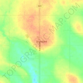
Name: Standard topographic map, elevation, terrain.

Location: Standard, Wheatland County, Alberta, Canada (51.09245 -113.00021 51.13245 -112.96021)

Average elevation: 2,917 ft

Minimum elevation: 2,851 ft

Maximum elevation: 2,972 ft

Other topographic maps

Click on a map to view its topography, its elevation and its terrain.

Siksika Nation

Canada > Alberta > Wheatland County

Average elevation: 3,025 ft

Stobart Lake

Canada > Alberta > Wheatland County

Average elevation: 2,979 ft

Redland

Canada > Alberta > Wheatland County

Average elevation: 2,700 ft

Gear up for your next adventure:

🛌Ultralight Sleeping Bags - Compact down bags for cold nights in the wilderness
📱Solar Portable Charger - Solar power bank for charging devices off‑grid
🏥Hiking First Aid Kits - Comprehensive medical kits for remote trail injuries
🗃️Trail First Aid Kit - Essential kit for outdoor injuries and emergencies
📶Vehicle Signal Boosters - Improve reception in rural areas while driving to trailheads

As an Amazon Associate, this site earns from qualifying purchases at no extra cost to you.