
Make a donation
Gear up for your next adventure:
As an Amazon Associate, this site earns from qualifying purchases at no extra cost to you.
Niederbiel topographic map
Click on the map to display elevation.
Make a donation
Gear up for your next adventure:
As an Amazon Associate, this site earns from qualifying purchases at no extra cost to you.
About this map
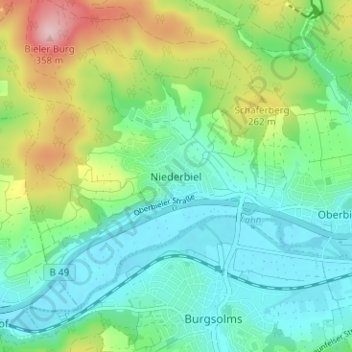
Name: Niederbiel topographic map, elevation, terrain.
Location: Niederbiel, Solms, Lahn-Dill-Kreis, Hessen, 35606, Deutschland (50.53619 8.37948 50.57619 8.41948)
Average elevation: 663 ft
Minimum elevation: 453 ft
Maximum elevation: 1,171 ft
Make a donation
Gear up for your next adventure:
As an Amazon Associate, this site earns from qualifying purchases at no extra cost to you.
Other topographic maps
Click on a map to view its topography, its elevation and its terrain.
Oberndorf
Deutschland > Hessen > Lahn-Dill-Kreis > Solms
Oberndorf liegt in einem Talkessel am Solmsbach, der sich hier zwischen bewaldeten Berghängen tief in die letzten Ausläufer des Hintertaunus am Lahntal eingegraben hat. Auf dem Bergrücken im Südwesten ist das hochgelegene Braunfels nur wenige Hundert Meter von Oberndorf entfernt, während die Gemarkung im…
Average elevation: 725 ft