
Make a donation
Gear up for your next adventure:
As an Amazon Associate, this site earns from qualifying purchases at no extra cost to you.
Oberndorf topographic map
Click on the map to display elevation.
Make a donation
Gear up for your next adventure:
As an Amazon Associate, this site earns from qualifying purchases at no extra cost to you.
Oberndorf
Oberndorf liegt in einem Talkessel am Solmsbach, der sich hier zwischen bewaldeten Berghängen tief in die letzten Ausläufer des Hintertaunus am Lahntal eingegraben hat. Auf dem Bergrücken im Südwesten ist das hochgelegene Braunfels nur wenige Hundert Meter von Oberndorf entfernt, während die Gemarkung im Osten die bewaldeten Berghänge mit der ehemaligen Grube Ferdinand und die 289 Meter Höhe erreichende Kammlinie bis kurz vor Laufdorf einschließt. Nördlich von Oberndorf ist die Bebauung mit Burgsolms zusammengewachsen und südlich befindet sich in etwa vier Kilometer Entfernung der Braunfelser Stadtteil Bonbaden.
Make a donation
Gear up for your next adventure:
As an Amazon Associate, this site earns from qualifying purchases at no extra cost to you.
About this map
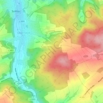
Name: Oberndorf topographic map, elevation, terrain.
Location: Oberndorf, Solms, Lahn-Dill-Kreis, Hessen, Deutschland (50.50829 8.39781 50.53459 8.44571)
Average elevation: 725 ft
Minimum elevation: 489 ft
Maximum elevation: 984 ft
Make a donation
Gear up for your next adventure:
As an Amazon Associate, this site earns from qualifying purchases at no extra cost to you.
Other topographic maps
Click on a map to view its topography, its elevation and its terrain.