
Wellen topographic map
Click on the map to display elevation.
About this map
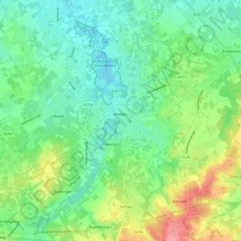
Name: Wellen topographic map, elevation, terrain.
Location: Wellen, Tongeren, Limburg, Belgium (50.81175 5.26477 50.86760 5.37224)
Average elevation: 197 ft
Minimum elevation: 108 ft
Maximum elevation: 381 ft
Other topographic maps
Click on a map to view its topography, its elevation and its terrain.
Maasmechelen
Belgium > Limburg > Tongeren > Mechelen-aan-de-Maas > Maasmechelen
The plateau of Campine was built up during the ice age with deposits of sand and other material that the Meuse river had eroded in the upstream Ardennes region. The higher elevation and the proximity of fertile river clay made this location an attractive one for the prehistoric tribes who established…
Average elevation: 157 ft