Geolocate

Orient topographic map

Click on the map to display elevation.

About this map

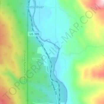
Name: Orient topographic map, elevation, terrain.

Location: Orient, Ferry County, Washington, United States (48.84601 -118.22278 48.88601 -118.18278)

Average elevation: 1,962 ft

Minimum elevation: 1,368 ft

Maximum elevation: 3,419 ft

Ferry County trails, hiking, mountain biking, running and outdoor activities

Other topographic maps

Click on a map to view its topography, its elevation and its terrain.

Keller

United States > Washington > Ferry County > Keller

Average elevation: 2,218 ft

Ferry Lake

United States > Washington > Ferry County

Average elevation: 3,432 ft

Inchelium

United States > Washington > Ferry County

Average elevation: 2,096 ft

Wiseman Island

United States > Washington > Ferry County > Pollard

Average elevation: 2,549 ft

Gear up for your next adventure:

🌎3D Topographic Globes - Raised relief globes for a tactile understanding of geography
🪶Compact Camp Shovel - Folding shovel for campsite tasks
🧥Men's Rain Shells - Premium waterproof and breathable jackets for mountain weather
☀️Outdoor Sunscreen - High protection sunscreen for outdoor activities
📷Action Camera - Capture your outdoor adventures in HD

As an Amazon Associate, this site earns from qualifying purchases at no extra cost to you.