Geolocate

Sugar Valley topographic map

Click on the map to display elevation.

About this map

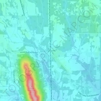
Name: Sugar Valley topographic map, elevation, terrain.

Location: Sugar Valley, Gordon County, Georgia, 30746, United States (34.53814 -85.03189 34.57814 -84.99189)

Average elevation: 682 ft

Minimum elevation: 604 ft

Maximum elevation: 1,168 ft

Gordon County trails, hiking, mountain biking, running and outdoor activities

Other topographic maps

Click on a map to view its topography, its elevation and its terrain.

Ranger

United States > Georgia > Gordon County

Average elevation: 827 ft

City of Plainville

United States > Georgia > Gordon County

Average elevation: 699 ft

Gear up for your next adventure:

📚USA Hiking Guide Books - Top trail guides and map books
🧭Orienteering Set - Complete compass and map reading kit
🗺️Topographic Maps - Detailed topo maps for hiking, exploring and outdoor navigation
😴Insulated Sleeping Pads - Compact and warm pads for high-elevation camping
🔭Compact Binoculars - HD vision for scouting terrain and identifying distant landmarks

As an Amazon Associate, this site earns from qualifying purchases at no extra cost to you.