Geolocate

Wedowee topographic map

Click on the map to display elevation.

About this map

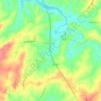
Name: Wedowee topographic map, elevation, terrain.

Location: Wedowee, Randolph County, Alabama, United States (33.28210 -85.51115 33.32919 -85.46418)

Average elevation: 912 ft

Minimum elevation: 774 ft

Maximum elevation: 1,079 ft

Randolph County trails, hiking, mountain biking, running and outdoor activities

Other topographic maps

Click on a map to view its topography, its elevation and its terrain.

Newell

United States > Alabama > Randolph County

Average elevation: 938 ft

Wedowee

United States > Alabama > Randolph County

Average elevation: 912 ft

Flat Rock

United States > Alabama > Randolph County

Average elevation: 830 ft

Gear up for your next adventure:

👖Convertible Hiking Pants - Versatile zip-off pants for changing altitudes and temperatures
🎒Outdoor Daypacks - Lightweight backpacks designed for carrying maps and essential gear
📖Nature Tracking Books - Learn to track wildlife and terrain
🪑Ultralight Camp Chairs - Portable seating for resting after a long day of mapping
🧦Merino Wool Socks - Moisture-wicking, blister-preventing socks for long treks

As an Amazon Associate, this site earns from qualifying purchases at no extra cost to you.