
Newell topographic map
Click on the map to display elevation.
About this map
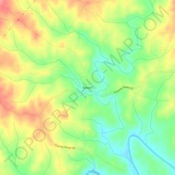
Name: Newell topographic map, elevation, terrain.
Location: Newell, Randolph County, Alabama, 36270, United States (33.41317 -85.45356 33.45317 -85.41356)
Average elevation: 938 ft
Minimum elevation: 807 ft
Maximum elevation: 1,079 ft
Randolph County trails, hiking, mountain biking, running and outdoor activities
Other topographic maps
Click on a map to view its topography, its elevation and its terrain.