
Cellarhead topographic map
Click on the map to display elevation.
About this map
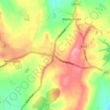
Name: Cellarhead topographic map, elevation, terrain.
Average elevation: 787 ft
Minimum elevation: 607 ft
Maximum elevation: 951 ft
Other topographic maps
Click on a map to view its topography, its elevation and its terrain.
Stepping Stones
United Kingdom > England > Staffordshire > Staffordshire Moorlands
Average elevation: 735 ft
Onecote
United Kingdom > England > Staffordshire > Staffordshire Moorlands
Average elevation: 1,014 ft
Cheddleton
United Kingdom > England > Staffordshire > Staffordshire Moorlands
Average elevation: 669 ft
Biddulph Grange Country Park
United Kingdom > England > Staffordshire > Staffordshire Moorlands > Biddulph > Biddulph Moor
Average elevation: 751 ft
Rudyard Lake
United Kingdom > England > Staffordshire > Staffordshire Moorlands > Rudyard > Horton
Average elevation: 673 ft
Hales Hall Pool
United Kingdom > England > Staffordshire > Staffordshire Moorlands > Cheadle
Average elevation: 597 ft
Waterhouses
United Kingdom > England > Staffordshire > Staffordshire Moorlands
Average elevation: 938 ft
Draycott in the Moors
United Kingdom > England > Staffordshire > Staffordshire Moorlands
Average elevation: 581 ft
Werrington
United Kingdom > England > Staffordshire > Staffordshire Moorlands
Average elevation: 715 ft
Forsbrook
United Kingdom > England > Staffordshire > Staffordshire Moorlands
Average elevation: 623 ft
Fawfieldhead
United Kingdom > England > Staffordshire > Staffordshire Moorlands
Average elevation: 1,020 ft
Ladderedge Country Park
United Kingdom > England > Staffordshire > Staffordshire Moorlands > Leek
Average elevation: 577 ft
Checkley
United Kingdom > England > Staffordshire > Staffordshire Moorlands > Checkley
Average elevation: 545 ft
Butterton
United Kingdom > England > Staffordshire > Staffordshire Moorlands
Average elevation: 974 ft
Dimmingsdale Valley
United Kingdom > England > Staffordshire > Staffordshire Moorlands > Alton
Average elevation: 581 ft
Alton Castle
United Kingdom > England > Staffordshire > Staffordshire Moorlands > Alton
Average elevation: 505 ft
Caverswall
United Kingdom > England > Staffordshire > Staffordshire Moorlands
Average elevation: 709 ft
Consall
United Kingdom > England > Staffordshire > Staffordshire Moorlands > Consall
Average elevation: 709 ft
Hollinsclough
United Kingdom > England > Staffordshire > Staffordshire Moorlands
Average elevation: 1,165 ft
Endon Basin
United Kingdom > England > Staffordshire > Staffordshire Moorlands > Endon
Average elevation: 587 ft
Alstonefield
United Kingdom > England > Staffordshire > Staffordshire Moorlands
Average elevation: 915 ft
Werrington
United Kingdom > England > Staffordshire > Staffordshire Moorlands
Average elevation: 715 ft
Caverswall
United Kingdom > England > Staffordshire > Staffordshire Moorlands
Average elevation: 709 ft