
Make a donation
Gear up for your next adventure:
As an Amazon Associate, this site earns from qualifying purchases at no extra cost to you.
Waterhouses topographic map
Click on the map to display elevation.
Make a donation
Gear up for your next adventure:
As an Amazon Associate, this site earns from qualifying purchases at no extra cost to you.
About this map
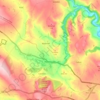
Name: Waterhouses topographic map, elevation, terrain.
Average elevation: 938 ft
Minimum elevation: 499 ft
Maximum elevation: 1,247 ft
Make a donation
Gear up for your next adventure:
As an Amazon Associate, this site earns from qualifying purchases at no extra cost to you.
Other topographic maps
Click on a map to view its topography, its elevation and its terrain.
Werrington
United Kingdom > England > Staffordshire > Staffordshire Moorlands
Average elevation: 751 ft
Biddulph Moor
United Kingdom > England > Staffordshire > Staffordshire Moorlands
Average elevation: 794 ft
Stepping Stones
United Kingdom > England > Staffordshire > Staffordshire Moorlands
Average elevation: 735 ft
Bottomhouse
United Kingdom > England > Staffordshire > Staffordshire Moorlands > Ipstones
Average elevation: 1,024 ft
Make a donation
Gear up for your next adventure:
As an Amazon Associate, this site earns from qualifying purchases at no extra cost to you.
Roughcote
United Kingdom > England > Staffordshire > Staffordshire Moorlands > Caverswall
Average elevation: 712 ft
Blackshaw Moor
United Kingdom > England > Staffordshire > Staffordshire Moorlands > Thorncliffe
Average elevation: 925 ft
Make a donation
Gear up for your next adventure:
As an Amazon Associate, this site earns from qualifying purchases at no extra cost to you.
Horton
United Kingdom > England > Staffordshire > Staffordshire Moorlands > Gratton
Average elevation: 653 ft
Merryton Low
United Kingdom > England > Staffordshire > Staffordshire Moorlands
Average elevation: 1,352 ft
Rushton Spencer
United Kingdom > England > Staffordshire > Staffordshire Moorlands
Average elevation: 669 ft
Make a donation
Gear up for your next adventure:
As an Amazon Associate, this site earns from qualifying purchases at no extra cost to you.
Wetley Rocks
United Kingdom > England > Staffordshire > Staffordshire Moorlands
Average elevation: 751 ft
Old Hannah's Hole
United Kingdom > England > Staffordshire > Staffordshire Moorlands > Wetton
Average elevation: 906 ft
Milk Hill
United Kingdom > England > Staffordshire > Staffordshire Moorlands
Average elevation: 899 ft
Make a donation
Gear up for your next adventure:
As an Amazon Associate, this site earns from qualifying purchases at no extra cost to you.
Moneystone
United Kingdom > England > Staffordshire > Staffordshire Moorlands > Cotton
Average elevation: 758 ft
Biddulph Grange Country Park
United Kingdom > England > Staffordshire > Staffordshire Moorlands > Biddulph > Biddulph Moor
Average elevation: 751 ft
Moneystone Quarry
United Kingdom > England > Staffordshire > Staffordshire Moorlands > Kingsley > Whiston Eaves
Average elevation: 663 ft
Rudyard Lake
United Kingdom > England > Staffordshire > Staffordshire Moorlands > Rudyard > Horton
Average elevation: 673 ft
Make a donation
Gear up for your next adventure:
As an Amazon Associate, this site earns from qualifying purchases at no extra cost to you.
Hales Hall Pool
United Kingdom > England > Staffordshire > Staffordshire Moorlands > Cheadle
Average elevation: 597 ft
Brown Edge
United Kingdom > England > Staffordshire > Staffordshire Moorlands
Average elevation: 646 ft
Cellarhead
United Kingdom > England > Staffordshire > Staffordshire Moorlands
Average elevation: 787 ft
Hope
United Kingdom > England > Staffordshire > Staffordshire Moorlands > Alstonefield
Average elevation: 899 ft
Make a donation
Gear up for your next adventure:
As an Amazon Associate, this site earns from qualifying purchases at no extra cost to you.
Hollington
United Kingdom > England > Staffordshire > Staffordshire Moorlands
Average elevation: 495 ft
Cauldon Lowe
United Kingdom > England > Staffordshire > Staffordshire Moorlands
Average elevation: 958 ft
The Roaches
United Kingdom > England > Staffordshire > Staffordshire Moorlands
Average elevation: 1,168 ft
Make a donation
Gear up for your next adventure:
As an Amazon Associate, this site earns from qualifying purchases at no extra cost to you.
Draycott Cross
United Kingdom > England > Staffordshire > Staffordshire Moorlands > Boundary
Average elevation: 600 ft
The Cloud
United Kingdom > England > Staffordshire > Staffordshire Moorlands
Average elevation: 636 ft
Upper Tean
United Kingdom > England > Staffordshire > Staffordshire Moorlands
Average elevation: 574 ft
Ladderedge Country Park
United Kingdom > England > Staffordshire > Staffordshire Moorlands > Leek
Average elevation: 577 ft
Make a donation
Gear up for your next adventure:
As an Amazon Associate, this site earns from qualifying purchases at no extra cost to you.
Flash
United Kingdom > England > Staffordshire > Staffordshire Moorlands
Flash is a village in the Staffordshire Moorlands and the Peak District National Park, England. At 1,519 feet (463 m) above sea level, it is the highest village in the United Kingdom (some sources claim a height of 1,531 feet (467 m) for Wanlockhead in Scotland, but a survey in 2019 showed that there are no…
Average elevation: 1,352 ft
CBeebies Land
United Kingdom > England > Staffordshire > Staffordshire Moorlands > Farley
Average elevation: 548 ft
Dimmingsdale Valley
United Kingdom > England > Staffordshire > Staffordshire Moorlands > Alton
Average elevation: 581 ft
Make a donation
Gear up for your next adventure:
As an Amazon Associate, this site earns from qualifying purchases at no extra cost to you.
Thorncliffe
United Kingdom > England > Staffordshire > Staffordshire Moorlands
Average elevation: 1,024 ft
Alton Castle
United Kingdom > England > Staffordshire > Staffordshire Moorlands > Alton
Average elevation: 505 ft
Totmonslow
United Kingdom > England > Staffordshire > Staffordshire Moorlands > Huntley
Average elevation: 558 ft
Make a donation
Gear up for your next adventure:
As an Amazon Associate, this site earns from qualifying purchases at no extra cost to you.
Huntley
United Kingdom > England > Staffordshire > Staffordshire Moorlands > Huntley
Average elevation: 584 ft
Endon Bank
United Kingdom > England > Staffordshire > Staffordshire Moorlands > Endon
Average elevation: 630 ft
Lower Lee
United Kingdom > England > Staffordshire > Staffordshire Moorlands > Meerbrook > Lower Lee
Average elevation: 866 ft
Make a donation
Gear up for your next adventure:
As an Amazon Associate, this site earns from qualifying purchases at no extra cost to you.
Thor's Cave
United Kingdom > England > Staffordshire > Staffordshire Moorlands > Grindon
Average elevation: 886 ft
Endon Basin
United Kingdom > England > Staffordshire > Staffordshire Moorlands > Endon
Average elevation: 587 ft
Cellarhead
United Kingdom > England > Staffordshire > Staffordshire Moorlands
Average elevation: 787 ft
Make a donation
Gear up for your next adventure:
As an Amazon Associate, this site earns from qualifying purchases at no extra cost to you.