Geolocate

Gould topographic map

Click on the map to display elevation.

About this map

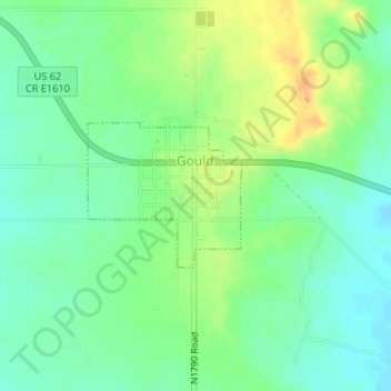
Name: Gould topographic map, elevation, terrain.

Location: Gould, Harmon County, Oklahoma, 73544, United States (34.66347 -99.78025 34.67350 -99.76724)

Average elevation: 1,617 ft

Minimum elevation: 1,575 ft

Maximum elevation: 1,677 ft

Harmon County trails, hiking, mountain biking, running and outdoor activities

Other topographic maps

Click on a map to view its topography, its elevation and its terrain.

McQueen

United States > Oklahoma > Harmon County

Average elevation: 1,522 ft

McKnight

United States > Oklahoma > Harmon County

Average elevation: 1,736 ft

Madge

United States > Oklahoma > Harmon County

Average elevation: 1,913 ft

Gear up for your next adventure:

🌲Outdoor Survival Books - Best books on survival skills
🔥Fast-Boil Camping Stoves - Efficient cooking systems for quick trail meals
🛡️Bear Spray Outdoor - Protection in bear country hikes
👟Men's Trail Runners - Lightweight footwear for fast-paced exploration and light hiking
📱Solar Portable Charger - Solar power bank for charging devices off‑grid

As an Amazon Associate, this site earns from qualifying purchases at no extra cost to you.