
Make a donation
Gear up for your next adventure:
As an Amazon Associate, this site earns from qualifying purchases at no extra cost to you.
Arlington Station topographic map
Click on the map to display elevation.
Make a donation
Gear up for your next adventure:
As an Amazon Associate, this site earns from qualifying purchases at no extra cost to you.
Arlington Station
Arlington Station (formerly, Arlington) is a former unincorporated community, now annexed to Riverside in Riverside County, California. It lies at an elevation of 817 feet (249 m). Arlington Station is located on the Atchison, Topeka and Santa Fe Railroad, 6 miles (9.7 km) southwest of downtown Riverside.
Make a donation
Gear up for your next adventure:
As an Amazon Associate, this site earns from qualifying purchases at no extra cost to you.
About this map
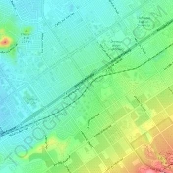
Name: Arlington Station topographic map, elevation, terrain.
Average elevation: 827 ft
Minimum elevation: 732 ft
Maximum elevation: 1,050 ft
Riverside County trails, hiking, mountain biking, running and outdoor activities
Make a donation
Gear up for your next adventure:
As an Amazon Associate, this site earns from qualifying purchases at no extra cost to you.
Other topographic maps
Click on a map to view its topography, its elevation and its terrain.