Geolocate

Pink Hill topographic map

Click on the map to display elevation.

About this map

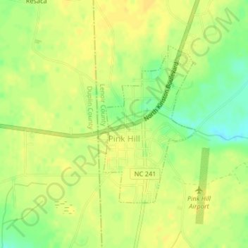
Name: Pink Hill topographic map, elevation, terrain.

Location: Pink Hill, Lenoir County, North Carolina, United States (35.04819 -77.74912 35.06533 -77.73677)

Average elevation: 141 ft

Minimum elevation: 89 ft

Maximum elevation: 161 ft

Lenoir County trails, hiking, mountain biking, running and outdoor activities

Other topographic maps

Click on a map to view its topography, its elevation and its terrain.

Savannah

United States > North Carolina > Lenoir County

Average elevation: 69 ft

Closs

United States > North Carolina > Lenoir County

Average elevation: 33 ft

Branchwood

United States > North Carolina > Lenoir County

Average elevation: 102 ft

Gear up for your next adventure:

🎒Hydration Pack - Hands‑free water reservoir for long hikes
🚗GPS Dash Cams - Record your scenic drives through mountain passes and canyons
💧Water Purification System - Clean water on the trail with reliable purifiers
🌲Outdoor Survival Books - Best books on survival skills
🪶Survival Guide Book - Expert advice for emergency preparedness

As an Amazon Associate, this site earns from qualifying purchases at no extra cost to you.