
Thank you for supporting this site ❤️
Make a donation
Make a donation
Gear up for your next adventure:
As an Amazon Associate, this site earns from qualifying purchases at no extra cost to you.
Altstadt-Lehel topographic map
Click on the map to display elevation.
Thank you for supporting this site ❤️
Make a donation
Make a donation
Gear up for your next adventure:
As an Amazon Associate, this site earns from qualifying purchases at no extra cost to you.
About this map
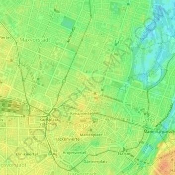
Name: Altstadt-Lehel topographic map, elevation, terrain.
Location: Altstadt-Lehel, Munich, Bavaria, Germany (48.13087 11.56483 48.15657 11.59817)
Average elevation: 1,709 ft
Minimum elevation: 1,647 ft
Maximum elevation: 1,765 ft
Thank you for supporting this site ❤️
Make a donation
Make a donation
Gear up for your next adventure:
As an Amazon Associate, this site earns from qualifying purchases at no extra cost to you.
Other topographic maps
Click on a map to view its topography, its elevation and its terrain.