Geolocate

Caorle topographic map

Click on the map to display elevation.

About this map

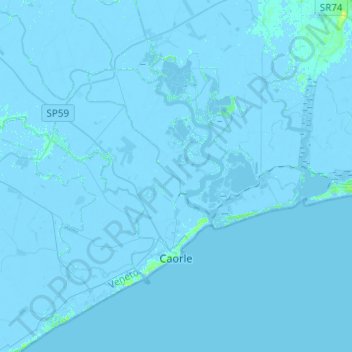
Name: Caorle topographic map, elevation, terrain.

Location: Caorle, Venezia, Veneto, 30021, Italy (45.55696 12.74278 45.71865 12.98810)

Average elevation: -3 ft

Minimum elevation: -16 ft

Maximum elevation: 33 ft

Other topographic maps

Click on a map to view its topography, its elevation and its terrain.

Tessera

Italy > Veneto > Venezia > Venice

Average elevation: 3 ft

Canale delle Fondamenta Nuove

Italy > Veneto > Venezia > Venice > Lido

Average elevation: 3 ft

Ca' Emiliani

Italy > Veneto > Venezia > Venice > Marghera

Average elevation: 10 ft

Sant'Angelo della Polvere

Italy > Veneto > Venezia > Venice

Average elevation: 0 ft

Murano

Italy > Veneto > Venezia > Venice

Average elevation: 3 ft

Cortellazzo

Italy > Veneto > Venezia > Jesolo > Cortellazzo

Average elevation: -3 ft

Pellestrina

Italy > Veneto > Venezia > Venice > Pellestrina

Average elevation: 0 ft

Bibione Pineda

Italy > Veneto > Venezia

Average elevation: 0 ft

Gear up for your next adventure:

🧤Hiking Gloves - Protective gloves for rugged trails
☀️Outdoor Sunscreen - High protection sunscreen for outdoor activities
🩳Quick‑Dry Hiking Shorts - Comfortable and quick‑dry shorts for summer hiking
🪶Survival Guide Book - Expert advice for emergency preparedness
🚑Emergency Bivvies - Heat-reflective sleeping bags for survival situations

As an Amazon Associate, this site earns from qualifying purchases at no extra cost to you.