
Make a donation
Gear up for your next adventure:
As an Amazon Associate, this site earns from qualifying purchases at no extra cost to you.
Paris Mountain State Park topographic map
Click on the map to display elevation.
Make a donation
Gear up for your next adventure:
As an Amazon Associate, this site earns from qualifying purchases at no extra cost to you.
Paris Mountain State Park
Paris Mountain lies in the Piedmont region of the United States. The mountain is a monadnock, a mountain that stands alone in an area. The word "monadnock" comes from Mount Monadnock in New Hampshire. The elevation of Paris Mountain exceeds 2,000 feet (609.6 m). The Piedmont region where Paris Mountain is located is a raised plateau. The Piedmont, which means "foot of the mountain", covers a third of South Carolina and contains several other monadnocks in addition to Paris Mountain.
Make a donation
Gear up for your next adventure:
As an Amazon Associate, this site earns from qualifying purchases at no extra cost to you.
About this map
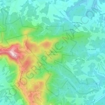
Name: Paris Mountain State Park topographic map, elevation, terrain.
Average elevation: 1,237 ft
Minimum elevation: 938 ft
Maximum elevation: 2,034 ft
Greenville County trails, hiking, mountain biking, running and outdoor activities
Make a donation
Gear up for your next adventure:
As an Amazon Associate, this site earns from qualifying purchases at no extra cost to you.
Other topographic maps
Click on a map to view its topography, its elevation and its terrain.
Hudson Acres
United States > South Carolina > Greenville County > Greenville
Average elevation: 1,004 ft
Make a donation
Gear up for your next adventure:
As an Amazon Associate, this site earns from qualifying purchases at no extra cost to you.
Morningside
United States > South Carolina > Greenville County > Wade Hampton
Average elevation: 984 ft
Make a donation
Gear up for your next adventure:
As an Amazon Associate, this site earns from qualifying purchases at no extra cost to you.
Lake Lanier
United States > South Carolina > Greenville County > Lake Lanier
Average elevation: 1,152 ft
Hampton Forest Apartments
United States > South Carolina > Greenville County > Wade Hampton
Average elevation: 1,004 ft
Make a donation
Gear up for your next adventure:
As an Amazon Associate, this site earns from qualifying purchases at no extra cost to you.
Georgia Street Park
United States > South Carolina > Greenville County > Fountain Inn
Average elevation: 843 ft
Make a donation
Gear up for your next adventure:
As an Amazon Associate, this site earns from qualifying purchases at no extra cost to you.
Kendall Green
United States > South Carolina > Greenville County > Greenville
Average elevation: 978 ft
Make a donation
Gear up for your next adventure:
As an Amazon Associate, this site earns from qualifying purchases at no extra cost to you.
Marshall Forest
United States > South Carolina > Greenville County > Greenville
Average elevation: 912 ft
Make a donation
Gear up for your next adventure:
As an Amazon Associate, this site earns from qualifying purchases at no extra cost to you.
Make a donation
Gear up for your next adventure:
As an Amazon Associate, this site earns from qualifying purchases at no extra cost to you.
Make a donation
Gear up for your next adventure:
As an Amazon Associate, this site earns from qualifying purchases at no extra cost to you.
Grace Point
United States > South Carolina > Greenville County > Grace Point
Average elevation: 925 ft
Make a donation
Gear up for your next adventure:
As an Amazon Associate, this site earns from qualifying purchases at no extra cost to you.
Powderhorn
United States > South Carolina > Greenville County > Simpsonville > Powderhorn
Average elevation: 850 ft
Make a donation
Gear up for your next adventure:
As an Amazon Associate, this site earns from qualifying purchases at no extra cost to you.
Mountain View Homes
United States > South Carolina > Greenville County > Greenville
Average elevation: 981 ft
The Vintage Apartment Homes
United States > South Carolina > Greenville County > Greenville
Average elevation: 1,001 ft
Make a donation
Gear up for your next adventure:
As an Amazon Associate, this site earns from qualifying purchases at no extra cost to you.